Bray, Valentia
Hut sites, Cross inscribed stones and Rock art
Valentia Island is best known for the spectacular views from Geokaun mountain across Valentia harbour, the Skellig Islands and the Dingle Peninsula, but for the modern antiquarian the scenery is just a bonus. The island is also littered with vast array of historical monuments ranging from the tetrapod trackway, made during the Devonian period, about 400 million years ago to the Megalithic and Early Christian sites at Cool East, Coarha Beg, Glanleam and the lesser known Early Medieval landscape at Bray. This medieval landscape includes, corn-drying kilns, cultivation ridges, enclosures, field systems, houses and souterrains.
.jpg)
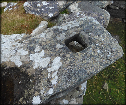
On the south-side of the road leading to Bray head, there's a group of five hut sites, the most interesting of these huts is pictured above, the Skellig Islands can be seen in the background, far right. The drystone hut is almost square internally, it measures 5.75 metres by 5.6 metres. Within the hut are twelve decorated stones, most of them bear rough equal armed crosses, Each stone has been assigned a letter, from A-L. I have idenified some of the stones shown below. Stone I, pictured below left, has four circles picked through the quartz surface. Stone J, below right, bears three concentric circles. Stone A is a two metre long rectangular stone in the the south side of the entrance passage, it bears a large cross with slightly expanded terminals. In 1912 Westropp and Henry noted two slabs near the entrance with perforations for door-frame posts, see bottom image.

Stone I

Stone J

Stone A
Situated: From Portmagee, travel acroos the bridge to Valentia island. c.1K turn left. After 2.4 k park at the loop Car-park. walk about 700 metres along the track at the west end of the car-park. The hut sites are about 250 metres south of here.
Discovery Map 83: V 3385 7322. Last visit July 2021.
Longitude: 10° 24' 51.0 " W
Latitude: 51° 53' 12.3" N
Photos: José Gutiérrez.